In 2009, I was doing a moonlighting job in Northern Arizona--- a Banner Health Urgent Care clinic needed weekend coverage. It was good money and they paid my mileage and accommodation (great for a poor resident like me!). It was a fun job, too, as the clinic was very near to the Grand Canyon, so lots of the patients were tourists from around the globe.
One Saturday afternoon, a couple in their 70's came in. Their English wasn't so great and I could sense a French accent. I asked them where they were from, expecting "Paris" or some French city. They replied, "Nouvelle Caledonie."
Huh? After their visit, I returned to my office and googled it. I saw the gorgeous photos of this South Pacific Island called New Caledonia and said to myself, "I *must* go there!"
Mind you, this was 3 years ago, before working in New Zealand was ever even a thought in my mind.
So, earlier this month I had a week between locums positions, and a super duper cheap flight from Auckland to Noumea (the capital of New Caledonia) came up, so it was time!
Below you can see just where New Caledonia is in relation to New Zealand--- another lovely South Pacific Island.... and closer to the equator, meaning WARMER! :)

(thanks honeymoonpacific.com for the map)
New Caledonia is known as the "French of the South Pacific." It is a special sort of French Territory (I don't understand all the details.) French is their official language. The currency is the South Pacific franc. The population is around 245,000. There are many Europeans here, but the indigenous population known as the Kanaks outnumber the Europeans. The Kanaks organize themselves in clans and live in tribes all over the main island and surrounding islands.
I was very excited for this trip. I thought it'd be great to soak up all the French culture, especially since I've never been to France.
Bienvenue! (Welcome!)
So, the island is long and skinny (one brochure referred to it as shaped like a baguette!) and my in my trip research I'd read that driving is easy. So I booked a 'self drive' tour- which included a rental car, told me where to drive, and booked the accommodation for me, too. Thank goodness, as I couldn't imagine trying to book things myself over the phone en Francais! (I took French in high school and some in college, but haven't used it since then, so obviously 'tres rusty'!) :)
First day. A bit cloudy, but my first impression was how green the island was. Even greener than NZ!
Here's a map. The airport was just north of Noumea, so the planned 5-day 4-night itinerary was drive along the west coast up to Kone (stay in Kone one night), drive across the island to Hienghene (stay in Hienghene two nights), then drive down the east coast and over to Noumea (stay overnight in Noumea), then leave the next morning. Whirlwind tour!
(thank you cdc.gov for the map)
So the first fun part of the trip was getting used to driving on the RIGHT hand side of the road again!
They had plenty of weird road signs, too. I thought this one was to warn me of hissing snakes ahead...
Nope, no snakes....it just was to warn you of a windy road :)
Also there were plenty of these "cross-out" signs...
They were always found when leaving a city. Basically, this one is telling you "If you're trying to get to Pwarairiwa or Ponerihouen, you're going the wrong way!!" Clever and helpful.
I had a little trip itinerary given to me by the travel agency of some sights to see. Unfortunately, sights were not that well signposted (and all the signs were in French only). I was frustrated on that first day because of this. I had picked up some stuff for lunch and was looking forward to a nice picnic.
It wasn't until almost 3pm when I actually located something I was supposed to see... Turtle Bay, aka "Baie des Tortues"
Turtles don't live here anymore, but the rock and cave formations are pretty neat. The pointy rock on the picture above is known as the Pierced Rock, "La Roche Percee".
There were some neat carvings on a stump..
And some very tall curvy trees.
I was SO excited to plop down and have my first picnic lunch at the beach!
Pique nique a la plage!
Baguette (of course), chevre (I can eat this stuff by the spoonful it's so delicious), saucisson, Orangina (the diet verson just doesn't compare to the original), and biscuit chocolat. MMMM..
So, I found my way to Kone (not many more sights to be seen/found along the way, just driving), and spent the night in the hotel there. The next morning I was off to Voh, to hike to see the magical "Heart of Voh", this natural phenomenon where a mangrove swamp is in the perfect shape of a heart, when viewed from above. Apparently you can only see it by helicopter or hike. I opted for the cheaper, more physically active option.
However, I drove to the town and found no signs. After 15 minutes of circling this tiny town, I went into the pharmacy and asked (en Francais, of course). I pointed to the heart picture on my brochure, and was able to comprehend that the parking lot was across from the cemetery. Found the cemetery, found the parking lot, even found a sign that had a map for a hiking trail! I thought I was doing well.
HOWEVER, I must've not been on the right trail, as I hiked the outlined loop on the sign, and saw no heart anywhere. The views were still ok, though.
And I also discovered these guys, who would quickly slither off the track as you approached them.
In my (very scientific) google research to figure out what they actually are, I *think* they are skinks, a type of lizard with short necks and short legs.
After the heartless hike, it was time to start the drive through the center of the baguette and across the country to the East Coast. The tourbooks didn't lie when they said it was a scenic drive. And thankfully there were many places to stop, that were indeed well marked and easy to find!
An awesome lookout picnic spot..
Pique-nique a la montagne!
Baguette, jambon (ham), chevre, pomme (apple), and Coke Zero :)
I walked down to the river and rocks seen in the distance--- another nice place to stretch your legs after all the driving.
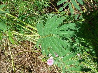
At another park, I spotted this!! I was so excited!!!
No, this is not just another fern. New Zealand is like the fern capital of the world, and I've searched all over NZ to find THIS fern. I haven't seen this fern since about the 1980s--- as my grandparents had one in their house, and I was in love with it. Look closely above.....
Now look!
Can you see? After touching it, all the leaves close up! It is the Mimosa pudica, aka the "Sensitive plant" or "touch-me-not". It's native to Central and South America, but I guess you can find them all over now. Call me a dork, but you have *no* clue how many ferns I've touched on my hikes in NZ to try to see if they were one of these. Alas, I found it in New Caledonia!
So, the drive across the country did have some spectacular views.
The east coast proved to be pretty beautiful, too.
Even though I had trouble finding the actual tourist sites, there was quite a bit to look at on the journey. Every dozen km's or so you'd sign a sign for another tribe. There'd often be a few roadside stands, selling fruit, veggies, flowers, shells, etc.
I really appreciated seeing all the different village churches. They were all well maintained, freshly painted, and easy to spot. You could sense they were definitely a place of importance for the villages.
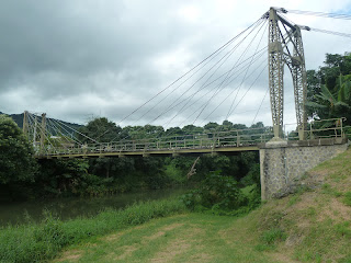
The next striking thing were the bridges. Some were downright scary!
Others were sturdy, yet primitive...
And some were quite historic, such as the Passerelle Marguerite, which has been around since 1909!
So, back to the route. After crossing the country from west to east, I arrived in the village of Hienghene (don't ask me how to pronounce it, I'd mess it up every time I tried!). The resort village booked for me was great-- instead of a room, you stayed in a bungalow.
The resort was on the coast, and my bungalow looked out to the Pacific Ocean. The resort had snorkel gear for guest use, so of course I had to check it out, as New Caledonia has the 2nd largest double-barrier coral reef in the world (behind Australia's Great Barrier Reef).
Since I was spending two nights here, I had a day free of driving and navigating. THANK GOODNESS.
A morning snorkel, an afternoon hike, and then I arranged to have a traditional dinner at a house in one of the local Kanak tribes.
The population of Hienghene is less than 3,000, with 97% being Kanak--- so tourists were pretty much the only white people in this town.
The land has some beautiful rock, cliff and coast formations... such as this, "La Poule Couveuse"...
aka "The Brooding Hen". Pretty accurate, eh?
This was supposed to be a Sphinx, but I think it takes a bit too much of your imagination to see that...
The lady at the Hienghene Visitors Centre only spoke French, but spoke it slow and comprehensible enough for me to get the gist of a local hike to try, to the col de Ga Wivaek. A col is a ridge or a saddle between two peaks. The start of the trail was very well marked, so I had a good feeling I'd actually make it to where I planned.
And YES- after a sweaty hour, I got to the 'col'! And there was even a sign there telling me "Bravo" for reaching it!
(I'm a sucker for positive reinforcement)
The view was great.
There were also good views of les Roches de Linderalique, towering black limestone rock formations.
So, after a nice sweaty hike, I cleaned myself up and went back to the Tourist Info Centre as the slow speaking French lady was to give me directions to the village I was going to for dinner. She explained it is customary in Kanak culture to give a small gift when first entering the house/village, and then you would be welcomed. She said it didn't matter what it was, it was the thought that counted. I had no clue what to give, as I didn't have much, and it wasn't like there was a Mall around the corner or anything--- but I did have some New Zealand gummy candy and a headband from Peru in my car, so that's what it had to be! She said that would be fine.
I was scared and VERY very nervous--- stomach churning, I hadn't been this nervous in a long time! I was about to go into a strange village, by myself, for dinner, at a strangers house who spoke NO ENGLISH.
But I did it!
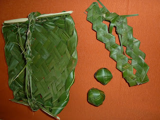
I didn't take many pictures, as I didn't want to be disrespectful (and it was getting dark). But the village was very basic--- dirt roads, aluminum roof shacks--- electricity yes, and the teenage girl who showed me around indeed had a cellphone. For a small fee, her aunt would show me dressage before dinner. I looked at her confusingly--- where were the horses? Then she moved her hands like weaving, and it wasn't until I read the guestbook from other French visitors where it's actually "tressage" from the verb "tresser", which means "to braid". So, I paid the lady a few francs and she showed me how to do this..
Definitely far from horse competitions. :)
One of those little ball things in the picture was made by yours truly! The Kanak auntie made all the other more complicated things. That's talent!
One of those little ball things in the picture was made by yours truly! The Kanak auntie made all the other more complicated things. That's talent!
I was looking forward to dinner... my stomach was now churning due to hunger and no longer due to nerves. It was slightly odd, as there were around 8 or 10 around the house and yard, but the table oustide was only set for two. Just the auntie and I dined together, and everone else ate around the corner, peaking at us occasionally. Weird.
Here is a soup made from plantains, noodles, and a leafy green vegetable I believe is called "chou canaque" (for Kanak cabbage). It was pretty good.
I thought the soup was all we were eating, but then the teenage girl brought out the main course, beef marinated in soy sauce (she almost had to bring out the Soy Sauce bottle from the kitchen to get me to understand what 'soya' was) and coconut rice. And I had a chocolate pudding cup for dessert (how authentic, ha).
All in all it was a different but good experience. Very simple, no bells and whistles. To get up the guts to go was definitely my biggest challenge in quite some time! But after 3 hours of full-on conversing in French and only French, I can see why immersion language programs can be so successful!
So, the next morning, I left Hienghene. I had LOTS of driving to do---- to the tune of 6 hours south to Noumea on windy village roads. There were heaps of locals hitchhiking and I got nasty looks when I didn't stop, but 1- this girl's gotta stay safe, and 2- I had to get driving!
I was getting exhausted when I was about an hour outside of Noumea. The roads were definitely getting more highway-like as the city approached. There started to be all these signs saying "peage"---- I was getting excited as it was getting closer--- 5km, 2km, 1km, 500meters... I figured it was a rest stop or something big/exciting. But all of a sudden BOOM there was a toll booth in front of me! Whew, lucky I had some random New Caledonia coins in my wallet to muster up the toll fee. So much for a rest stop!
Originally I was looking forward to getting to the "big city" of Noumea and exploring, because I thought I was sure to find more French culture here than in the previous small towns/villages. But once I arrived, all I wanted to do was CRASH!
So here's my hotel room. Kind of Frenchy in decoration, eh?
I took a power nap and then went for a jog along the coast of the Baie des Citrons. I forced myself to get all fancied up and go out for one nice dinner on my last night in New Caledonia. I was recommended to try a restaurant called "L'Astrolab".
To keep with the culture, I ordered snails for an appetizer. Escargot! It was delicious. I will definitely eat them again.
For my main course I had I had shrimp in a banana/Baileys sauce, and potato gratin and coconut rice. And Peach Melba for dessert. Delicious!!
And, as a partying gift, some French guy at the table on my RIGHT had these flowers from the strolling flower selling lady delivered to my table.
Oh la la!
Not to be beat, a guy on the table on my LEFT then had a glass of champagne delivered to my table.
On the start of my trip, my mom warned me about the French men! Boy, she was right. :)
Unfortunately not much more of Noumea was seen by me other than the run, the restaurant, and my hotel--- I was just too exhausted!
All in all, it was an okay vacation. Quite difficult to navigate by car when French isn't your first language. Less French culture in the outlying villages than I was expecting. But still, delicious food, pretty sights, and some gorgeous beaches.
Au revoir, Nouvelle Caledonie!


