Monday, July 16, 2012

All Things Volcanoes, with Pete

I have a friend named Pete.  He is from England but lives in Auckland.  He is in grad school studying mathematical models of shark brains (aka he is smart).  When I want to do something fun, even if it's during the week when most people are working, he is always keen.  Over the past few months we've been doing several activities involving volcanoes.

The first involved Mount Eden, the neighborhood in Auckland right next to where Pete lives.  Mount Eden is a cinder cone located 5km from the city center.  It's the highest natural point in all of Auckland, so the views are great.  The coolest thing though, is that it's a dormant volcano with a huuuuge crater in the middle.
You can walk around the edge but you're not allowed into the crater.  (Wouldn't that make an awesome sledding hill if it actually snowed in Auckland?)   Mount Eden was formed from an eruption 28,000 years ago.   It's dormant now and not expected to erupt again (thank goodness--- or Auckland would be screwed!)

Here's Pete and I posing with the crater.  He's pretending to be taller than me.

Our next volcanic adventure involved a day trip out to this place--- Rangitoto Island.
Rangitoto is a relatively young volcanic island, just a short ferry ride away from Auckland.  It formed about 600 years ago in a series of dramatic explosions.   At the time people were living on the island right next to it, Motutapu.  Can you imagine, just one day, hearing an explosion and a new island popping up next to you?  Wild!

In the early 20th century there were a handful of people living in simple beach baches along the coast.   Now no one lives there, and it's a nature reserve. 

A one hour trek leads to the top (260 meters), and you can look down into the crater.
Definitely a contrast in vegetation compared to Mount Eden!

Here are Pete and I at the top of the crater, with Auckland city in the distance.


Windy day!

Zooming in on the views of Auckland....

Near the top of the crater there were some lava tubes to explore.  Here's Pete heading into one.

It was quite dark inside the caves!  I had my trusty torch on my cellphone.  Didn't help much, it was still pretty dark. :)

The trails up, down, and around the crater all looked like this--- no dirt, minimal green--- just lots of lava rock.

And here was the ferry that took us back to Auckland.  Fun day!

But just wait, there's more volcanic adventures with Pete!

Below in the distance is Mount Pirongia, about an hour and a half drive south of Auckland.  Mount Pirongia is... you guessed it... an extinct volcano, this one rising up to 959 meters (3146 feet).  There's a hut near the summit and several tramping tracks leading to the top.  Pete was keen for a tramp, so off we went! 

Mount Pirongia is actually part of a decent sized forest park.  We were stoked that the park offered two little cabin accommodation thingees at the base of the park and start of the tramp.  They were cozy and comfy and WARM  (we were warned that our hut at the top had no fire, no stove, no source of heat... and the predicted Pirongia temperature that evening was 1degree C (and that was at sea level--- the hut was at 900 meters!)

(Oh, and in case you plan on visiting the town of Pirongia, do NOT, I repeat, do NOT show up hungry.  We did, and there is literally nowhere to eat in this one-horse town.  However, if you drive about 20km, you'll get to Te Awamutu, which has an amaaazing Roast Dinner Place. Mmmm.)

Here's Pete in the morning, packing up his pack after our last night of warm and comfy sleep.

One hour into the hike and still smiling!  (Only about five hours to go)

At the Ruapene Trig, our first break.

The views from Ruapene Lookout.  Nice Day, lots of green down there!

Next step was making it over to those green hills in the distance.  Onward!

Next up were passing the Tirohanga Bluffs, some nice, hard, volcanic lava.  Someone recommended we take a side trip up to the top.  It was a bit of climbing, but worth it!

A few more hours and we reach the highest point of the walk, the Pirongia Summit.   Beautiful views from 959 meters in the sky!

We were almost to the hut when we saw these cage like things on the side of the track.  What the????
Yeah, so the Dept of Conservation uses dogs to help control the goat population.   Here are the kennels where the dogs stay when they're out on a hunting trip (no room in the hut for the poor doggies).  Crazy!  First time I've ever seen dog kennels on a tramping track!

So, about 5 or 6 hours of steady walking uphill, we made it to the Pahautea Hut.  Success!
It was a simple little thing with 6 bunks and a cooking area.  No fire or stove or anything other than warm clothes and our sleeping bags to keep us warm.  We were joined by an interesting ex-army man who lost his job, lost his wife, and just might've been living in that hut for the past several days.  A bit creepy, but also a bit amusing.  Was real glad Pete was there too to keep me safe from the slightly eccentric man!


Before sunset, we took a wander to the helipad nearby as eccentric man told us the views were great.    
Check it out--- that's Mount Ruapehu!

And there's Mount Taranaki! 

It was a chilly night in the hut, but not too horrible.   Putting on cold wet boots and socks the next morning was the worst, though.   Plus, check out the creepy crawler who decided to bless my boots with his presence!
After extensive online research by Pete and myself, it was determined this was not a spider after all but a "harvestmen", more commonly known as daddy long legs.   They don't bite, thankfully, but they're still creepy to find on your boot first thing in the morning!


The walk down from from the hut was long and technical.   Some fun chains to grab onto where the rocks were big.  Unfortunately the views were crap, as it was a very foggy day.

We passed the time by Pete teaching me all sorts of English slang that us Yanks have never heard of... like "kip", "peckish", "chuffed", and many other words that I've already forgotten.   Crikey, those bloody Brits have a language all of their own!  :)


About four hours later, we made it to the bottom of the track.  Success!  
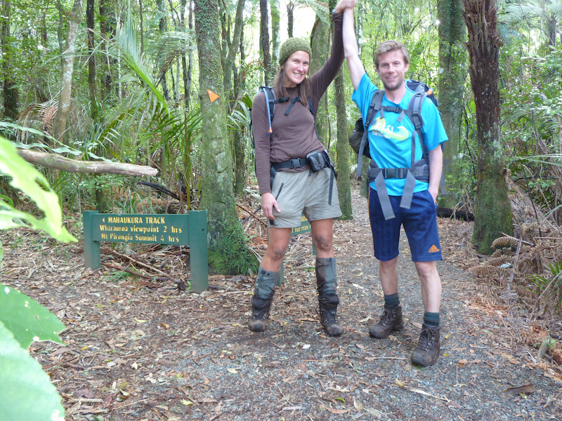
Mount Eden, Rangitoto, and Mount Pirongia--- a trifecta of fun volcanic adventures with my mate Pete.

Sunday, July 15, 2012

At the Tippy Top: Northland

Told ya it wasn't going to be another 2 months til the next blog!  :)
As you know, I've explored lots of New Zealand, making it as far east (East Cape) and pretty far south (Invercargill).   Since I was working up north in the Bay of Islands, I figured I must go allll the way up and see NZ's most northern point, Cape Reinga.
 
(thanks doc.govt.nz for the map!)


So, I left work on Friday afternoon from the Bay of Islands (see map) and started driving north.  I found a nice Holiday Park at Houhoura Heads, a beachside town on the eastern coast up the peninsula.   Their cabins were being rennovated, and it was a little too chilly for camping, but they had another very cool option--- stay in someone else's camper!  
Many people chose to leave their campers here all year round, for a slight fee.   Some of them choose to rent them out to strangers (like me).  So, it was sort of a risk (as I had no clue what'd be like), but it ended up being great!   A cozy little camper with bed, tv, sink, stove... perfect for just me (and Smokey parked outside!)

The next morning I got up real early, stocked up on snacks and gas (shops and gas stations are nonexistent in the far far north), and headed to the tippy top of New Zealand.


The attraction up here is the Cape Reinga Lighthouse. It's actually fairly new--- built in 1941.  It replaced another lighthouse that used to be on a nearby island, but rough seas made access to the island very dangerous.  Thus, a mainland lighthouse was created.

I was so glad I arrived early, as no other tourists were there besides me.  I'd say it was calm and peaceful, but it wasn't--- the wind was absolutely howling!


This stretch of Northland has great significance to the Maori.   Cape Reinga's Maori name is "Te Rerenga Wairua", meaning Leaping Place of the Spirits.   This area is the geographic location where the Tasman Sea meets the Pacific Ocean, where, according to Maori belief, the male sea meets the female sea.   The waves crashing together (there were a lot of them!) symbolizes the coming together of male and female- the creation of life.   According to Maori mythology, it's also the place where spirits jump off and leave the mainland on their way to the afterlife.

A prime example of the crashing waves and colliding waters of the seas...

So, just south of Cape Reinga along the western edge of the peninsula was this--- Te Werahi Beach.  I was amazed at how gorgeous it was--- probably my most favorite beach looks-wise in all of New Zealand!
There is a walking track all along this coast--- if I only had 3 whole days (and a walking companion) to do it with me!

Next up was a drive down to see the infamous Te Paki Sand Dunes and Ninety Mile Beach.... aka tons and tons of endless sand.

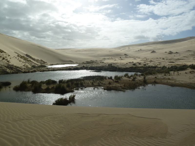
A popular tourist attraction is boogieboarding down the dunes.   Driving on the beach is possible, but pretty risky, especially if you don't have 4WD.  I wasn't it the mood to go boogieboarding all by myself, so I just sat in the carpark and watched some of the tourists do it.   All of a sudden a huge mud covered truck comes grumbling and splashing in off the beach.  To make a long story short, this guy was quite friendly (and by no means threatening), so I hopped in his "ute" (truck) and he took me for a 4WD adventure down the beach! Then the crazy guy started driving his truck UP the dunes and we ended up here-- an actual lake that was surrounded by mounds of sand in every direction!

The crazy Kiwi guy went for a swim in it.  Brr!   Here's a pic to just some a bit of perspective of how massive these dunes were (and how far away we were from the ocean or any road!).


He then asked me if I had seen the Aupouri Forest yet--- one of the largest man made forests in the Southern Hemisphere.   I hadn't, so then began my 4WD tour of that!   

He stopped the truck suddenly and peered out my window at this.
Linz:  "Whatcha looking at?"
Kiwi guy:  "All that mess!  Know what made that?"
Linz: "Ummm...no."
Kiwi guy:  "Pigs!   That looks fresh.  Wanna go pig hunting?"
Linz: "Ummm...ok?"

And then the next thing you know, he parks the ute, he lets his three pig dogs out of their box in the cab, the dogs go running, he grabs his knife and gun, and we're off.  Running through the woods following the lead of his (superfast) dogs.  Barefoot!   Jeez do I get myself in random situations or what?

Sadly, we didn't get a pig. But I did get a workout following those dogs! (And thankfully no splinters in my feet!).

Also spotted a great rainbow when my new Kiwi mate took me back to the carpark.


So, after an exciting day of exploring and 4WD'ing and pighunting, I had some fish n chips and called it an early night in my cozy camper.

The next morning I decided to learn a bit more about the Kauri forests in the area and headed to the "Gumdiggers Park".  It was an outdoor museum and "Gumfield" that was packed of info of just what gumdigging entails.   Northland was full of Kauri trees since the age of the dinosaurs.  Something--- no one is quite sure what (tidal waves, meteors...) caused the demise of these old forests.  Some of these trees have been preserved, and when Kauri trees are damaged, they produce a large amount of sap which covers the wounded tree and protects the inner timber.   This sap can congeal into hard lumps and fall to the ground, eventually turning into an amber-like stone.  

Kauri gum has many uses--- the Maori used it for chewing, tattooing, and lighting fires.  The Europeans that traded with the Maori found out it could be used for varnishing furniture, and kauri gum became quite a hot commodity.  Once the lumps that were visible on the ground were gone, folks started searching for it in the ground from trees fallen thousands of years ago--- and the industry of "gumdigging" was born!  

(I hope I'm not boring you here, but I found this all quite interesting!)

Gumdiggers would use long thin pokers and just keep poking the ground until they felt something hard (like the fossilized gum).  Then they'd dig a hole to dig it up.

Here at the Gumdiggers Park was a log of a Giant Kauri that was between 100,000 to 150,000 years old.  And massive to boot!


Below are a pair of what New Zealanders call "gumboots".  Probably most Kiwis would tell you they got their name from being made out of rubber/gum.... but according to the museum, this is false! The 19th century gumdiggers wore boots like these as they worked in swampy fields.  There ya go!

Here are some of the still intact holes the gumdiggers dug in the early 1900s.

All in all, it was a pretty awesome morning of learning about the Kauri forest and the gumdigging industry.

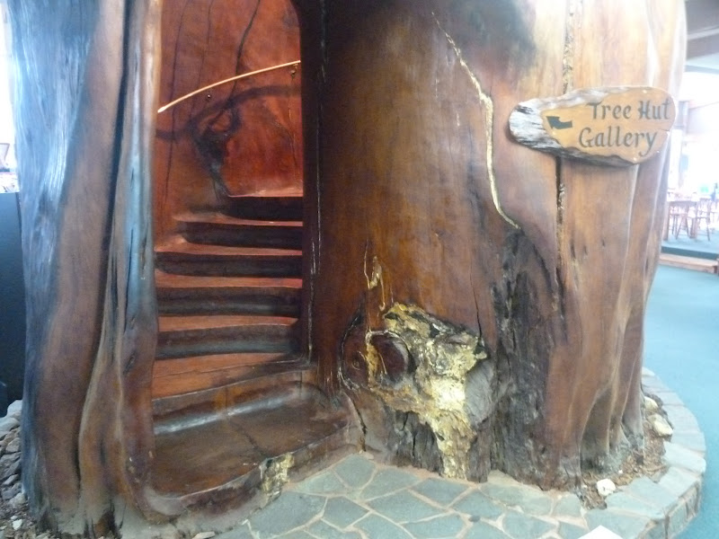
I found a cafe and gift shop further down the road with all things Kauri.  Check out the spiral staircase carved out of a Kauri tree trunk!  45,000 years old- wow!

Since I loved that Gumdiggers museum so much, I asked the owner for an itinerary for the rest of the day.  He gave me some great advice!

Here is the southern end of "Ninety Mile Beach" at Ahipara.    Gorgeous day.

Slight traffic jam, but nothing too bad.  ;)

I then kept traveling down the western coast of the peninsula.  Had to stop to see NZ's Oldest Bridge in the not-so-booming metropolis of Kohukohu.
How pitiful, huh?  Well, it has been around since the 1860s.   (Some towns will boast anything for tourism!)  

Next up was a carferry trip over the Hokianga Harbour.  Fun!  Smokey enjoyed the ride, too. :)

On the other side of the harbour was the State Highway 12, the route to the Waipoua Forest, where the Most Giant of the all the Giant Kauris can be found.

Here I am with Tane Mahuta, the largest known Kauri to stand today.  It's between 1500 and 2500 years old.  It's 51 meters (168 feet) tall!

A short walk away was NZ's 2nd largest Kauri, Te Matua Ngahere--- not quite as tall (30 metres) but it is thought to have the biggest girth of any tree in NZ-  16 meters (52 ft).  

After seeing quite possibly NZ's two most famous trees, it was time to pay my respects to NZ's most famous dolphin.  The town of Opononi was where a friendly dolphin was found to be playing with the local children after her mother had been killed.  "Opo" the Dolphin was a local celebrity and soon turned national celebrity back in the 1950s.   Kiwis adored her!  Songs and documentaries were made after her.  Sadly, she died in 1956, and she has a grave in her memory in the town of Opononi,.

RIP Opo.

Sorry to end on such a sad note, but that wraps up my time in Northland.   A great place to visit!
Til next blog!

Saturday, July 14, 2012

Getting Historic: Paihia and Russell

Ouch!   Has it been almost TWO months since I've blogged?
BAD, BAD LINDSAY!
Well I won't waste any time and I'll tell you about what I've been up to.

After New Caledonia, I took a 2 week position in Paihia, located up North in the "Bay Of Islands" area.   I've travelled there before, way back in 2010 on my first Labour Day long weekend.

Here's the town of Paihia, a small seaside village.   Booming in the summer, much quieter in the winter.


With these 2 week jobs, accommodation is provided, but it's like a box of chocolates (you never know what you're gonna get).   
I got REAL lucky this time--- it was an apartment attached to a GP's house who owned tons of land on a gorgeous farm a bit inland.
This was the view out of my bedroom window!

Yes, I did say it was a farm.  These guys were my neighbours.   What a hoot!

On one of my days off, I took a short ferry trip to the nearby town of Russell.

Small but quite charming coastal village.

This below is known as Flagstaff Hill (wonder why?)  Apparently this area was cause for much debate between the Maori and the British colonists who came to settle the area.   Maoris were angry when Union Jack flags were flown here and I guess the flagstaff was cut down four times in total by the Maori as rebellion.

A neato sundial was on the top of the hill, too.   11:00am, FYI :)

The views at the top of the hill look over to both Paihia and the town of Waitangi, where the treaty of Waitangi was signed back in 1840.

I took a walk to the far side of Russell to Takepa point and discovered these neat lava rocks.  Nice colour contrast with the vegetation, rock, and blue water below.


Russell has a beach called Long Beach...   A wee bit different and less populated than the American version in Long Beach, California!  Still pretty, though.

Russell has LOTS of history--- it's quite an old town by NZ standards.  Here is Christ Church, NZ's oldest church and possibly NZ's 3rd oldest building, built around 1835.

Remember how I said about the feuds between the Maori and the British back in the mid-1800s?  Well outside the church, you can still see some of the bullet holes from the muskets fired at the church walls!  Scary yet historic!

It was a surprise to see this huuuuge plant outside the church-- it was a pointsettia!

A few more of the historic sites of Russell include NZ's oldest restaurant, The Gables.  Unfortunately it was closed for the winter- boo!

And NZ's oldest licensed hotel, The Duke of Marlborough.

I finished the day with a tasty bowl of seafood chowder and took the ferry back across to Paihia.   A nice day exploring some New Zealand history.

Stay tuned for more adventures (coming MUCH sooner than 8 weeks, I promise!)